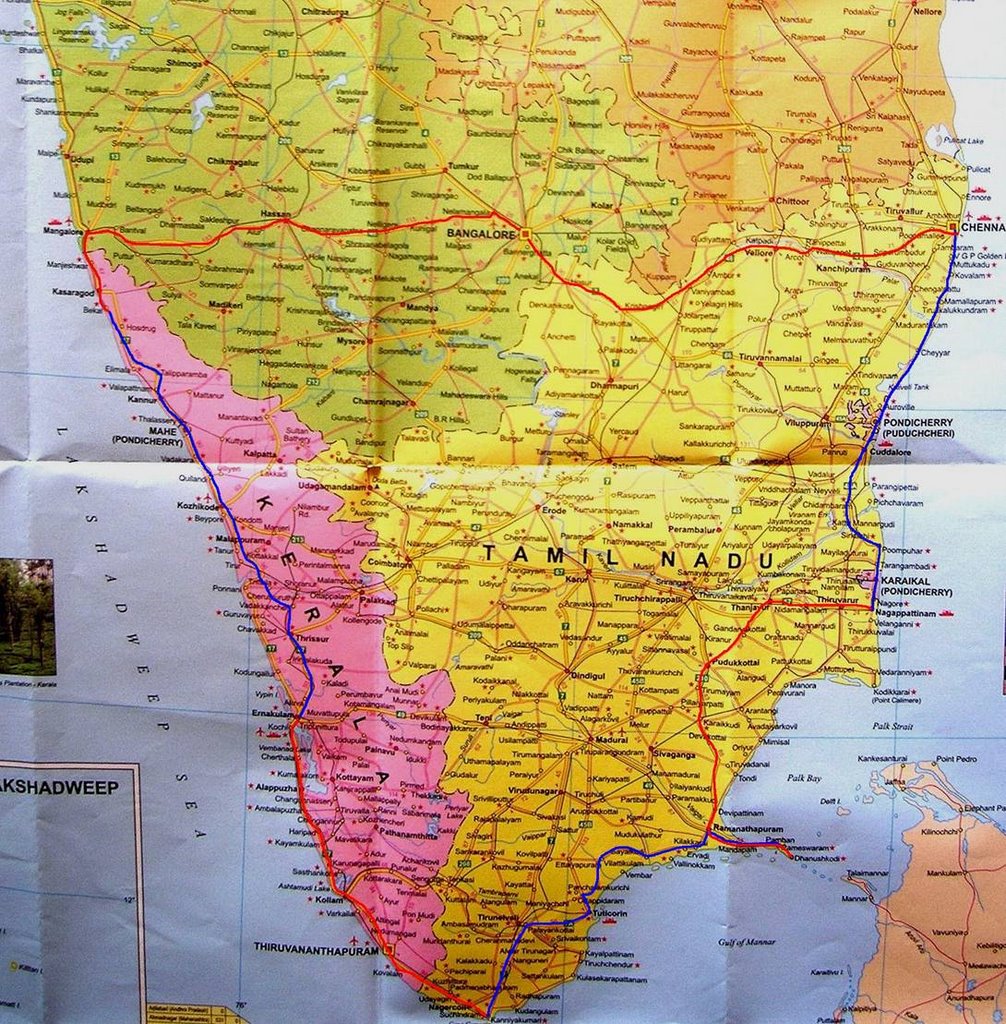
The Drive
Started as a thought way back in 1998 driving around Canada and the States. Drive all around the coast of India. Took 8 years in the making – need the long break, need a better car, need the right weather. Finally realization dawned that the trip was important more than the means.
If one imagines that the drive along the peninsular coast as a scenic drive close to the beach with the wind blowing across, sun shining merrily on the waters and the radiant beaches inviting you to stop… it’s a bit of a mirage. The only place along the peninsular path which comes close is the Eastern Coastal Road (ECR) between Pondicherry and Chennai – and you have to pay for driving on this. Nonetheless the drive has a charm which only India can offer – sheer variety.
The bustling traffic around Mangalore, the hilly terrain of northern Kerala, the bridges across the rivers hitting the sea in central Kerala, the winding road amidst the thousands of windmills near Kanyakumari, to the gusty lonely stretches along the green waters near Kanyakumari and the scenic ECR – the difference in terrain and landscape boggles you. And if you are gastronomically inclined add to this the different cuisines all along the coast. After a certain point of time, you don’t know what to expect. And that describes India in a nutshell.
A few things about the two major states along the path:
Kerala coast is one long city with lot of sub-urban towns which are always round the corner. Roads after monsoon are average and directions can be a bit tricky, though you are heading south all the time. Tamil Nadu is land of beautiful roads and inconsistent distances. Everything is give-or-take ten km. The critical directions are always are in Tamil J
This is a driving travelogue… city guides, tourist guides are available in plenty on the net.
Bangalore – Bekal Fort
Distance – 404 Km
Start with the familiar NH48 to Hassan. The road undivided in most of the places is still a pleasure to drive. With long sight of the road and sparse traffic – one can just gobble up the miles. Need to watch for the dogs running across the highway. Is it better to honk and warn the animal or just let it remain in ignorance while you pass? In spite of burning the tyre rubber hit one of the dogs. Fortunately, no damage was done. The ghat sections from Sakleshpur to Uppinangadi is a diff story – where is the highway? - washed into the copious river. An adventurous overtake by a heavily laden truck had left the highway completely blocked for heavy vehicle traffic. Trucks had backed up (neatly along the left of the road. God bless) for close to 10 km. Luckily, small cars could pass through. The overall ghat section is close to 100km and the river is gushing next to the remains of the road. The new bridge in Uppinangadi has eased the traffic. It’s a sight to watch the full Netravati at BC Road.
Hit the NH17 at Mangalore and drive across the innumerable bridges (including the big one at Ullal) into Gods own country – Kasargod, Kerala. The continuous sound of buses whizzing past can induce sleep. Bekal (Baikal) fort is 16 km south of Kasargod , along the Konkan railway line and off the highway.
Bekal Fort – Ernakulam
Distance – 384 km
Northern Kerala is hilly. The road winds around the lush green hills, offering glimpses of valleys with abundant greenery and crossing the innumerable bridges across the grey waters. At rare places when the road nears the sea, you can see the river joining the sea and the fishermen going about their business. The road is also intertwined around the Konkan railway line and cross innumerable times. So at many places you switch off, fume over the local buses on your right and wait.
In this part of Kerala, National Highway is the road in front of the house. People park, walk around, cross and treat it as such. It’s extremely tough to differentiate from the width and the quality of the road which one is a side road and which one is the National highway. Many stretches would hardly qualify (near Telicherry) as road let alone NH. Given that you are never more that 10 km from the next town, the road has a constant traffic of autos and jeeps ferrying people around.
Nevertheless, once you convince yourself that you are not in a race to get somewhere – things look much brighter. The steep climbs, the deep dives (there is one near Kottakal which makes your ears pop) start to seem like fun. There are some great stretches of road – near Guruvayur and the last 20 km to Ernakulam from Angamali– though there is heavy traffic.
An aggressive tourism drive has resulted in a flurry of milestones indicating temples, beaches and forts in the 200km vicinity. Yet among all these, it’s tough to figure out how far you are from the destination.
Till Calicut, you see milestones to Kochi, then it is suddenly dropped and you see distance to Edapally (which is few km from Ernakulam). Next you see milestones with distance to Fort Kochi and Ernakulam which suddenly drops as you get close and you get distances to Kanyakumari. If you are not careful, you will miss NH17 and hit Thrissur. From Thrissur it is NH 47 to Ernakulam.
Well, finally you get there – this way or the other. It is lush green all around and pouring cats and dogs. That’s bliss.
Ernakulam – Kanyakumari
Distance – 306 km
Ernakulam is on the mainland, Cochin on the peninsula. There’s a new bridge connecting across. This is flatish country and the roads are NH quality. A long stretch of divided highway between Kochi and Alleppy makes the drive less stressful. Around Alleppy is Kumarakom lake and the famous resorts around it. The road to Trivandrum from Alleppy is largely non-descript. Constant traffic and endless overtakes across ambitious bikers. Road tends to get hilly close to Trivandrum and the ride into the city requires lot of guidance.
The famed Kovalam beaches are 15km south of Trivandrum and have great roads leading up to it. Most of the beaches are private property of famous resorts. A peaceful half an hour at one of the beaches can rejuvenate for the rest of the drive.
A few miles of country road gets you back to the NH47 from Kovalam.
The road to Nagercoil is extremely hilly and curvy. It takes time around this busy section. This section gets you across the last of the western ghats and as you get close to Nagercoil, the sight of mountains covered with greenery is awesome. The clouds covering the mountain tops and threatening to drop down on one side and the imminent sea on the other is a unique landscape. Feel the breeze across the highway as you cross across Nagercoil and head to Kanyakumari. Drive along the beautiful road and head straight to the temple right in time for the sunset.
Kanyakumari – Rameshwaram
Distance – 347 km
The hotel manager warns that the road north of Tuticorin is ‘not good area if you are driving alone’.
The coastal police want to know your family history as you get out of Kanyakumari.
You get out onto NH7 to Tirunelveli a bit wary, but a few km an astonishing sight hits you. Thousands of windmills as far as you can see facing west to the mountains which are covered with dark clouds. Wind farms as they are called along the highway with all the fans rotating!
Don’t realize the km’s passing as Tirunelveli arrives. Friendly police direct you to Tuticorin along NH 7A. Tuticorin is a port town with a beautiful road with largely truck traffic leading to it.
After a brief visit to the beach – turn north along NH 45B to Madurai. A few km down the highway directions to Rameshwaram (164 km – Don’t believe it) eastward appear.
Veer eastward and you are off the highway. You realize it within the first km as the road turns from 2 lanes to half a lane. The 120 odd km to Ramanathapuram takes a good four hours to negotiate. Directions are largely by helpful locals who direct you to the right path among the 4 equally bad roads. The coastal police are omnipresent and very bored. They cheerfully help and note down all the details about you.
The roads are lined with palm trees – the red soil, green palm trees and deep blue sky make a striking vision. There is a cool breeze blowing across all the time and sea seems close by. There has been no rainfall here – though it has been pouring for months in Kerala.
After a four hour off-the-road drive (wished I had a SUV), you pour into NH49 at Ramanathapuram. This is the gateway to Rameshwaram and the drive across the amazing Indira Gandhi Bridge between Mandapam and Pambham. You have to pay to get across. The wind on the bridge is gale like and pushes the car as you drive across. Stop at the middle and experience the wind. There’s a bright view of the deep green sea and the hundreds of boat in the water (all pointing into the wind).
This is the pinnacle of the trip. Standing on the bridge – pushing against the wind, watching the boats bouy and the pleasant sunlight across the face – just awesome!
The road to Rameshwaram from Ramanathapuram is a breeze. Undivided but flat and great quality.
Rameshwaram – Nagapattanam
Distance – 351 km
Wake up and head further east! Yes, there is 16 km east of Rameshwaram to Dhanushkodi – the eastern most point. One cannot go all the way in a private vehicle- after around 9 km you need to park and take a four wheel drive on the sand to go to Dhanush kodi. The 9 km of road is arrow straight and has sea on both sides. At high tide the water cover some parts of the road and there is sand on the road. The road is fantastic and this is one unique stretch of road. Wish it just went up to SriLanka
After a chai, head back west via Rameshwaram back to Ramanthapuram. Across the bridge again!
North on NH 210 to Trichy. A friendly person warns that the road is being widened – please adjust.
The road has many small villages and towns and this is one of the populated parts of TN. At Podukottai – look for directions to Tanjavur. Navigation by distance is a bad idea – if you can’t read Tamil. Many places are 60 km away. Turn back after going 5 km astray and head on the right way to Tanjavur – which says “No Entry” but well – it’s the right road.
Nagapattanam is east of Tanjavur on NH67. After another guffaw with directions (out from Tanjavur there are many 4 road intersections- with a circle in between- all of them don’t have clear directions L), decided that it is better to ask then wander off. This is paddy country and the road snakes along the river and paddy fields. One mistake and you will be swimming across the river or lying in a paddy field. As you get close to Nagapattanam, there is a board every km indicating a new town – but no boards indicating how far from Nagapattam you are. It does not matter - you will hit the sea if you go too far.
Nagapattanam – Chennai
Distance – 300 km
First stop for the day – Chidambaram. North of Nagapattanam along the coast on NH 45A. The sea is never more than a few km away and the vehicle in front of you more than a few meters away. Karaikal which is a part of Pondicherry is extremely hustly-bustly and the road eases out as you get north. The road curves away from the sea as Chidambaram nears.
Pondicherry is the next destination and the road gets you back to the sea.
This is a pleasant drive. Good roads, nice breeze, view of the sea once in a while – is this the best?
A small sign board directs you to ECR at Pondy. Looks disappointing as you hit M G Road and the road is very narrow. Come Aurovile – things start clearing up. A huge board welcomes you to the scenic tollway called Eastern Coast Road. Within a few km you know what you are paying for – this is the most beautiful stretch of road along the entire coast and beautiful it is. Sea on one side of the road and salt dunes on the other. And the road is wide, banked and very clearly marked.
Did the stretch from the toll gate near Pondy to Mammalapuram (Approx 70 km?) without changing from 5 gear down. This must be a record of some sorts (Limca book sorts). Of course the large part of the credit goes to the road.
If the windmills around Kanyakumari were the most astonishing sight, the brief halt on the IG Bridge the most satisfying moment, then this stretch was the most idyllic drive of the entire journey.
Chennai is another 50 km up this road but the aggressive driving of the city takes over within a few km.
Chennai – Bangalore
Distance – 365 km
This is a beaten track. Yet with the new 4 lane highway along the entire stretch from Chennai to Bangalore (NH 48 via Vellore, Krishnagiri and Hosur) – you suddenly notice the landscape. The rocky mountains near Vellore and Krishnagiri, the road steeply making its way across the mountains, the large fields near Kanchipuram.
The km’s keeps getting gobbled away, the speedometer of your car amazes you in a few places – this is good commercial road. Get on-get to your destination-get off.
Home run on the highway in 5 hrs.
Statistics:
Car – Marulti Alto, Lxi
Travel Date: Sept, 2006
Total Distance – 2477 Km, 7 Days
Fuel: 120 litres